Showing posts with label Surfers Point. Show all posts

Friday, December 1, 2023

Headwaters to Ocean (H2O) Conference

The California Shore and Beach Preservation Association (CSBPA) and Beach Erosion Authority for Clean Oceans and Nourishment (BEACON) organized the 2023 Headwaters to Ocean (H2O) Conference.  This was the first big in-person gathering of professionals involved in watershed and coastal  health, restoration, and management since the COVID pandemic.

On Tuesday November 28, BEACON convened their science advisory panel and stakeholders for a morning meeting followed by lunch and guided tour of the Surfers' Point Managed Shoreline Retreat Project.  

H2O was a two day conference held in the Crowne Plaza Hotel on Ventura Beach on November 29-30. 

The H2O conference serves as a catalyst for collaboration across various fields, industries, institutions, and organizations united by their shared interests in topics related to water, oceans, coastal environments, sediment management, resilience, and the intersections between terrestrial and marine systems.  

A session on Surfers' Point included presentations from Paul Jenkin, Surfrider Foundation, Bob Battalio, ESA, Dave Hubbard, CRC, and Kiki Patsch, CSUCI.  The talks covered the history, engineering, dunes, and monitoring.


Paul Jenkin presented the lunchtime plenary talk, "A Lifetime of Coastal Activism; A Retrospective" or "Headwaters 2 Ocean; Ventura River, a Case Study"


H2O Conference Website: https://asbpa.org/2023/08/15/h2o-2023-conference/


Thursday, October 12, 2023

Surfers' Point Nature Based Solutions video


"Fighting Climate Change with Nature," a video produced by the Surfrider Foundation featuring the Surfers' Point Managed Shoreline Retreat project:


Thursday, June 1, 2023

Surfers' Point funding ok'd

 At the June 1st meeting of the California Coastal Conservancy the board approved $16,200,000 to the City of San Buenaventura (Ventura) to construct Phase 2 of the Surfers Point Managed Retreat Project, a sea level rise adaptation project that relocates existing infrastructure landward and restores beach dune habitat, in Ventura. 


Surfrider submitted a support letter saying:

Surfers’ Point has been the flagship campaign of the Ventura County Chapter of the Surfrider Foundation since its inception in 1991.  For more than 30 years our members have advocated for the community-based solution to coastal erosion offered by this project.  The construction of the first phase in 2011 has proven the efficacy of this approach and we look forward to completing the project.  In recent years the rapid loss of the remaining bike path and parking lot has increased the urgency to relocate this visitor serving infrastructure out of harms way.  Implementation of the proven buried cobble berm and sand dunes will restore nature-based resiliency to this extremely popular stretch of coast.

Construction will begin after Labor Day, 2024


On this blog: Surfers Point


Reference:

COASTAL CONSERVANCY Project No. 08-057-02 Staff Recommendation June 1, 2023


 In the News:

Ventura gets $16M to move crumbling path, parking lot farther from crashing waves


Friday, February 24, 2023

Surfers Point in the news

 Ventura made the news recently with the headline “Here's how one beach in Ventura County is trying an innovative strategy to combat erosion

February 17, 2023, VENTURA, Calif. (KABC) -- The severe storms that hit California this season could end up costing the state in excess of $1 billion.

Coastal communities seem to move mountains in an effort to slow the beach erosion that threatens life near the ocean. But about 10 years ago, Surfer's Point in Ventura County became the site of a test for a managed-retreat strategy as the best way forward.

"It's really the nature-based solution and finding ways to work with nature so that people can still access this area," says Bill Hickman, Southern California regional manager for the Surfrider Foundation.


Building on the success of the first phase of the project, the City of Ventura has submitted a grant application to pay for the construction of the $16 million “Phase 2” Managed Shoreline Retreat.  The project will relocate the damaged Fairgrounds beach parking and bike path and restore the shoreline with a protective cobble beach and dunes.  The State Coastal Conservancy will make a decision this summer.  


Thursday, February 2, 2023

Ventura Rivermouth after flood

On January 9, 2023, flows on the Ventura River peaked over 35,000 cfs.  At this flood stage overbank flows enter agricultural lands and flow through the RV Park and were high enough to flow over Highway 101 stopping traffic.  These flows exit to the ocean through the historic second mouth of the river in Emma Wood State park visible to the left in the photo below.  Although the official flows are not yet in, this was perhaps a once-in-a-decade flood similar to 2005.

High flows transport significant amounts of sediment down the river and into the Pacific Ocean.  A large cobble berm formed at the rivermouth and was transported along the shoreline at Surfers Point by the coinciding large Pacific swell.  Subsequent swells and tides continue to rearrange this berm, and sand has moved into the rivermouth with a reduced wave climate.  Surf conditions since the flood indicate nearshore sand bars, and this sand will move onshore making for wide beaches in the summer months.    


Ventura Rivermouth 1-10-2023


Taylor Ranch and RV Park upstream of Ventura Rivermouth 1-10-2023

Ventura Rivermouth 1-18-2023


Surfers Point 1-18-2023
Ventura Rivermouth 1-18-2023


Ventura Rivermouth 1-31-2023
(credit: Dr. K Patsch)

(All photos courtesy Rich Reid rich@richreidphoto.com except where noted)


Friday, March 18, 2022

Surfers' Point Phase II Update

The Surfer’s Point Working Group met on January 6, 2022 to discuss the final plans for Phase II of the Managed Retreat project.  The Final Design is expected to be completed in March of 2022.  

At their April, 2021 meeting, the California Coastal Commission approved (with conditions) modifications to the Surfers Point Managed Shoreline Retreat project in Ventura, CA.  Phase 2 will relocate the damaged oceanfront bike path and remaining parking lot back to Shoreline Drive and reconfigure day use parking to maintain beach access at the popular Surfers' Point in Ventura.  As part of the permitting conditions for the project, the California Coastal Commission added a requirement for EV charging stations to be installed, as well as a water quality monitoring plan to be developed prior to issuance of a construction permit.  Additional permit applications are pending with the USACE (Corps of Engineers) and RWQCB (Regional Water Quality Control Board)

On January 25th, 2022, the Ventura County Fairgrounds voted unanimously in support of the project after receiving a presentation from the City and its consultants.  Meeting minutes here.

The City currently anticipates a budget of $12,475,000 and is seeking grant funding to complete construction for Surfer’s Point Phase II. City staff are planning to hire a consulting team to pursue these grants and help identify additional opportunities for funding.  The California Coastal Conservancy is expected to open their Grant Application Period in summer of 2022 with $500 million for coastal resilience to be appropriated statewide.

The image below gives an overview of what to expect with the new parking arrangement:


Just as with Phase I, coastal restoration will include importing cobble and sand to construct dunes over a buried cobble berm as shown below.  This will restore a more natural beach and provide coastal protection for the new infrastructure.  


Monday, December 13, 2021

Surfers' Point Update 2021

Collapsed curbs along Surfers' Point, Nov 4, 2021

Although communication has been difficult during the Covid-19 pandemic, progress has been made on the Surfers' Point Managed Shoreline Retreat Project.  The Surfers' Point Working Group has not met since the 2019 lockdown, but a meeting has been scheduled in early January to update the stakeholders. 

Under a Prop 68 grant from the California Ocean Protection Council and sponsored by BEACON, the City of Ventura has been completing the Final Design for the second phase of the project.  At their April, 2021 meeting, the California Coastal Commission approved (with conditions) modifications to the Surfers Point Managed Shoreline Retreat project in Ventura, CA.  Phase 2 will relocate the damaged oceanfront bike path and remaining parking lot back to Shoreline Drive and reconfigure day use parking to maintain beach access at the popular Surfers' Point in Ventura.

In 2011, the California Coastal Conservancy funded $1.5M of the $3M "Phase 1" project, with cost matching through Federal TEA transportation funding.  Looking to the future, the prospect for securing grant funding for the construction of Phase 2 seems promising.  According to the Coastal Conservancy's website;

On September 23, 2021, Governor Newsom signed a budget bill that includes a total of $500 million for coastal resilience to be appropriated to the State Coastal Conservancy in Fiscal Years 2022-23 and 2023-24. This coastal resilience funding is part of the larger climate resilience budget package that demonstrates the State of California’s commitment to preparing for climate change impacts, including wildfire, extreme heat, drought, and sea level rise.

This funding provides an unprecedented opportunity to move the needle on coastal resilience. The State Coastal Conservancy recognizes the urgency and importance of preparing the coast, and the people and wildlife that depend on the coast, for sea level rise and other climate change impacts. We look forward to working with many partner organizations to make a difference for the health of the coast. 

And although it is not yet clear how it will be allocated, the new Federal infrastructure package allocates billions of dollars for projects to strengthen the country's resilience to climate change.  As with Phase 1 construction, this may be a potential source of matching funds for Surfers' Point.

The California Ocean Protection Council created a series of videos featuring the projects they sponsored throughout the state.  Surfers' Point is featured in the video below:


More on this blog:  Surfers Point

Other links:


Tuesday, August 3, 2021

Photopoint monitoring


Last week a "Photopoint monitoring" station was installed at Surfers' point, a collaboration between Surfrider and the Ventura Land Trust.  Photopoint utilizes a fixed camera mount to allow beachgoers to photograph the shoreline from fixed points in order to systematically capture changes in the vegetation, dune morphology, sea level rise, and beach evolution over time.


Surfrider Ventura Chapter coordinator Cassie demonstrates the new Photopoint at Surfers' Point

Photopoint Monitoring is an effective way to document environmental change over time, thereby providing historical information to aid decision-making by resource managers. Our objective is to document the natural/anthropogenic changes to the shoreline caused by dredging, seasonal changes, and king tides for ongoing research into sea level rise. 

Installation team, L to R: Katie, Cassie, and Dan


Tuesday, April 27, 2021

Coastal Commission approves Surfers' Point Phase 2


At their April, 2021 meeting, the California Coastal Commission approved (with conditions) modifications to the Surfers Point Managed Shoreline Retreat project in Ventura, CA.   Application No. 4-05-148-A1 (City of Ventura and 31st Agricultural District, Ventura) aims to modify portions of the Managed Retreat project to support the recently completed plans for Phase 2 of the project.

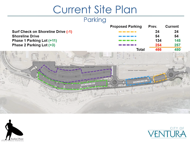
The project was originally approved in 2006, but due to limited funding only about half of it was constructed in 2010-11. These amendments to the original permit No. 4-05-148  reflect a revised layout of the parking lots which will increase the total available spaces for day use, overflow, and temporary surf check parking. (See the prior analysis of parking on this blog here)

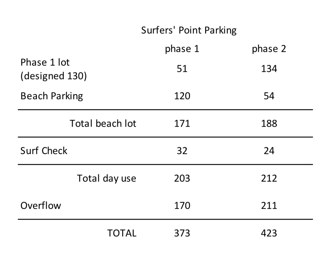
"The proposed reconfiguration would result in the addition of approximately 151 total parking spaces, approximately 64 of which would be located in the high frequency parking lot, and approximately 87 in the reduced frequency parking lot. [...] The proposed project reconfiguration would also add approximately three (3) twenty minute parking spaces that allow for drop-off or for the public to check water or surf conditions (these spots are called “surf check” parking spaces), for a total number of approximately 27 “surf check” parking spaces. Shoreline Drive is proposed to be relocated to improve circulation, with its terminus at the parking lot to be further east. The previously approved gatehouse/ticket booth located at the entrance of the parking lot would be relocated approximately 160 feet to the east, and a vehicle turn around would be added. 

"The surface material of the parking lot is also proposed to be changed from a permeable surface to asphalt. This change in surface material would also apply to the portion of the parking lot that was constructed in Phase 1 along with the new portions of parking lot to be constructed in Phase 2. [...] It was determined that the original turf grass parking lot is not feasible in current drought conditions and other permeable surfaces are infeasible as water is unable to adequately infiltrate due to the high ground water table.


Modifications to Parking Layout
Surfers Point phase 2


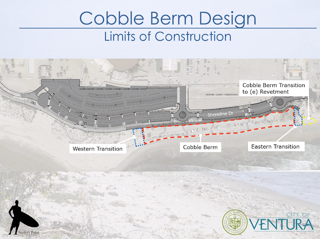
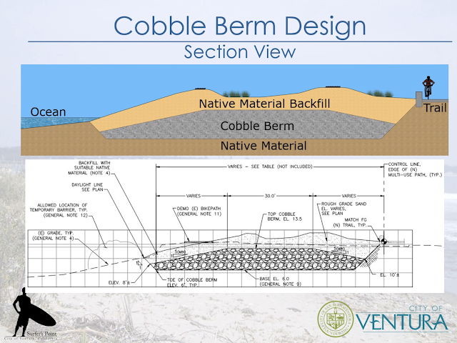
A separate permit (A-4-SBV-06-037) covers the "tidelands" portion of the project.   Phase 2 includes modifications to the originally approved managed retreat project to extend the cobble berm and vegetated sand dunes to merge with the promenade and recently constructed emergency revetment.  The changes would extend the cobble berm and vegetated sand dunes approximately 150 ft east (14,800 cu.yds. of cobble and 17,825 cu.yds. of sand), reconfigure public access amenities, and revise landscaping plan, at Surfer’s Point, City of Ventura, Ventura County. 


Modifications to Cobble Berm and Dunes
Surfers Point phase 2


The permit will require electric vehicle charging stations to be installed in the new parking lots:

The special condition to require electric vehicle charging stations is consistent with Coastal Act Section 30253 because it will reduce energy use and provide an opportunity for users of electric vehicles to access the coast. 

During discussion of the project, Coastal Commissioners Shelley Luce, Matt O'Malley, Mike Wilson, Mark Gold and Donne Brownsey raised concerns about the change of surface material of the parking lot, citing concerns over potential water quality impacts from runoff and uncertainty around mitigation of those impacts. Based on these concerns, Coastal Commission staff added a required Storm Water Management Plan (SWMP) and water quality monitoring condition into the permit amendment. The permit was approved unanimously.


Background

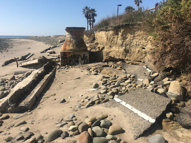
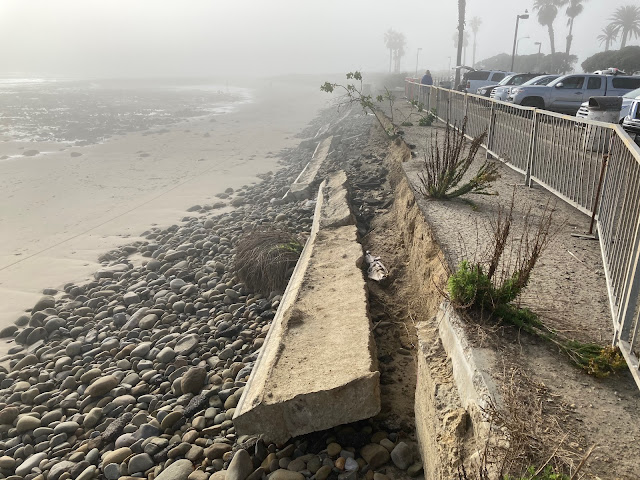
The Coastal Commission staff report includes an interesting summary of the history of the project dating back to the first bike path, located approximately two to 20 feet seaward of its current location, that had been partially destroyed by storms in the winter of 1982/3.  (Hints of this original bike path are visible along the eroding bluff today)

In 1984, the Commission certified the City of San Buenaventura’s Local Coastal Program (LCP) which created a 250-foot wide oceanfront corridor for recreational use, extending west from Surfer’s Point Park to the Ventura River.  The LCP was amended in 1986 such that "temporary bicycle and hiking trails...and temporary parking which do not require construction of a shoreline protective device, may be permitted within the setback area established by the geotechnical study.” 

In 1988 and 1989, the Commission approved two permits for improvements within the Commission’s original jurisdiction, CDP Nos. 4-88-123 and 4-88-130, that were associated with construction of Shoreline Drive, the 352-space parking lot, and other development in the oceanfront corridor at Surfer’s Point.

The oceanfront corridor improvements were constructed in 1989. In the summer of 1991, shoreline erosion began undermining portions of the bicycle path. 

In November 1991, Commission staff received a request from the City of Ventura/31st Agricultural District for an emergency permit to place five to six ton rocks along an approximately 260 foot length of the backshore in order to protect the bicycle path from erosion (CDP No. 4-91-060-G). The emergency request was denied in favor of relocating the undermined section of the bicycle path slightly inland. In explaining the Executive Director’s denial of CDP No. 4- 91-060-G, Commission staff noted that the improvements in the oceanfront corridor had been constructed on the understanding that they were temporary in nature and therefore could not be protected with shoreline protective devices. 

On December 11, 1992, following continued undermining of the bicycle path and parking lot, the City of Ventura issued itself an emergency coastal development permit for construction of a rip-rap revetment, and the revetment was constructed the following week, from December 14 – 16, 1992. Commission enforcement staff issued a stop work order on December 15, 1992, and further pursued removal of the revetment through enforcement and legal measures.

This emergency revetment remained in place until 2010 when it was removed along with the collapsing parking lot during construction of Phase 1 of the Managed Retreat project.


Commentary

Although the Surfers Point Managed Shoreline Retreat Project has been widely recognized as an innovative and effective approach to coastal management, it is just as much an example of failed coastal management.  Conflicting mandates and the inability to coordinate amongst the multitude of federal, state, and local government agencies has directly impacted this important public trust resource.  It is hard to quantify the benefits lost to decades of crumbling infrastructure and mismanagement at what should be the "crown jewel" of the City of Ventura.  This mismanagement stems from a lack of understanding and respect for the underlying dynamic landform of the Ventura River delta, combined with the bureaucratic failings of fragmented governance.   The fact that this issue has already lingered for four decades is stark foreshadowing to the future impact of sea level rise on the California coast.  In the meantime, we can only watch as the ocean slowly erases the mistakes of the past...


Reference

Coastal Commission Staff Report: Application No. 4-05-148-A1 (City of Ventura and 31st Agricultural District, Ventura)


On this Blog

Surfers Point (all posts)

Surfers’ Point Managed Retreat Phase 2 update, Oct 2020 - final plans and costs

Surfers' Point Phase 2 update, Dec 2019 - parking analysis

The Managed Retreat Process at Surfers Point, Nov 2010 - Phase 1 construction

Surfers' Point erosion damage Jan 2021 - current conditions

Natural Shoreline Case Study

Surfers' Point case study

Climate.gov (another case study)

US Climate Resilience Toolkit

Tuesday, February 16, 2021

Surfers' Point erosion damage Jan 2021


During the first week of February, 2021, the barriers along the eroding coastal path at the Ventura County Fairgrounds were moved back for public safety.  Several more parking spaces have been eliminated as the ocean continues to take back the beach.  


Erosion undermines the bke path,  Jan 13, 2021

This year's damage was more than anticipated, as relatively calm conditions were predicted with "La Nina" conditions dominating the Pacific Ocean.  However, an anomalous storm track developed producing a series of large swell events during the entire month of January, some coinciding with the year's highest tides.  Good for surfers, bad for beachfront property managers.

9 am January 14, 2021
(high tide 6.36 ft @ 9:30 am)

Large swell at Surfers Point, Jan 18, 2021

The final design for "Managed Shoreline Retreat" has been completed, but the process appears to be on hold.   Un-managed retreat continues... Fencing, concrete curb, and asphalt litter the shoreline along the most popular beach in Ventura County.


Overview looking east from the restored beach toward the eroding parking lot
slated for relocation in Phase 2 of the Managed Retreat project

Overview of Surfers' Point looking west - the parking lot in the foreground 
would be relocated out of harms way in Phase 2 of the Managed Shoreline Retreat project 


Artist rendition of the proposed Surfers Point Managed Shoreline Retreat project


Surfers' Point Managed Retreat Phase 1 - Jan 13, 2021
Phase 1 of the project continues to demonstrate resiliency to high surf
(note high tide line and exposed cobble berm)


Update from the City of Ventura:  
The City helped the Fairgrounds remove part of the wood fence, dig out the landscape area, pave the planting or parking area level with the path, and move the temporary fence over for some extra clearance from the eroded area. A few parking spaces had to be taken out to make it safe for pedestrians to pass. The hope is that this is enough to last through the summer, however that is weather dependent.
The City also reapplied for State Parks Division of Boating and Waterways – Public Beach Restoration Grant in the amount of $5.5M last month. This includes the beach side of the $10.1M estimate but not the new paved parking lot, lighting, and other amenities.

On this blog: 


Winter 2021 swells:


Friday, October 30, 2020

Surfers’ Point Managed Retreat Phase 2 update

 The final design for Phase 2 of the Surfers Point Managed Shoreline Retreat Project has been completed.  The proposed project will move the fairgrounds pay parking lot back to where Shoreline Drive is today and restore a cobble and sand dune beach as protection for the new parking area.  Unfortunately cost estimates came in at over $10M dollars, around twice the initial estimates.  We are concerned that this high cost may delay construction due to difficulty finding grant funding, but Surfrider will be working with the responsible agencies to determine a path forward.  Stay tuned…

More info here: https://www.venturariver.org/2019/12/surfers-point-phase-2-update.html


Tuesday, May 5, 2020

Promenade Emergency Repairs

Promenade revetment after construction, June 2020


During the week of January 6, 2020, City crews were notified of a large void beneath the Ventura Promenade. Upon inspection, it was discovered that the revetment and foundation material had eroded away.


Sandbag temporary protection, Ventura Promenade
February 8, 2020

The City initially pumped concrete to fill the void under the walkway to prevent collapse.

The final project phase consists of installing approximately 200 linear feet of up to 4-Ton size rock revetment along the beach side of the Promenade starting just east of the beach access stairs at Paseo de Playa. Work began the week of May 1 and access along the promenade will be blocked while construction is underway. More information here.


Equipment placing boulders, Ventura Promenade, May 5, 2020
(photo from webcam Surfline.com)

It has been almost a decade since the last time rocks were placed in front of the promenade.  At that time sufficient funding was not available for the planned improvements, including replacing the stairs and installing a shower at Paseo de Plaza.  As predicted, that section of the promenade will soon need a re-work.  


Ventura Promenade, ongoing erosion at the site of the last reinforcement in 2011

Work is currently being done under an Emergency Permit from the Coastal Commission.  By definition, the Coastal Act provides for "emergency" when "unforeseen" events occur.  Will this next section of the promenade be another "emergency" or will the City undertake comprehensive planning and budgeting to maintain our beaches?

Unfortunately this 50-year-old infrastructure is showing its age, and the cost of maintaining or replacing it may become untenable in the face of rising seas.

On this blog:   Ventura Promenade repairs, May 11, 2011

City of Ventura:  https://www.cityofventura.ca.gov/1142/City-Projects


Monday, December 16, 2019

Surfers' Point Phase 2 update

The Surfers Point Working Group met on October 29, 2019.

Final design of Phase 2 of the Surfers' Point Managed Shoreline Retreat project is ongoing.  The consultant team presented the latest design, with much of the discussion concerned lighting, fences, and other ammenties as well as a preliminary design for fixing the stormwater system to eliminate the problem with sand and silt clogging the filters and pumps.  The new parking lots will be paved with asphalt to eliminate erosion of silt and sand.  The runoff is to be filtered in bioswales at the bottom of the hill by the fairgrounds arena before being pumped up to the clarifier and out to the river mouth. The next step will include a coastal analysis for the beach side from the Phase 1 dune area down towards the bathrooms.

Last month, the City with assistance from BEACON applied for a $3M grant for construction.  This would cover about half the cost through a federal program administered by the National Fish and Wildlife Foundation (NFWF) for “Emergency Coastal Resilience Fund 2019

Due to ongoing concerns with parking layout, Surfrider submitted the following comments:


To: Surfers Point Working Group
From: Paul Jenkin, Surfrider Foundation
Date: November 27, 2019
RE: Working Group Meeting October 29, 2019

This memo is a follow up to our last Working Group meeting. During the meeting I repeated concerns regarding the parking layout that has been developed. It is important that the project takes advantage of the opportunity to optimize the quantity of parking, both for Fairgrounds operations and day use public beach access.

After reviewing the October 29 powerpoint presentation we would like to share a few comments:

First, it would be more representative of the project if the new “Shoreline Drive” parking lot was labeled the “Phase 2” lot, as it is in fact the completion of the currently existing “Phase 1” parking lot.

Second, the spaces in the future “Phase 2” overflow parking lot are counted as day use, which somewhat distorts the net gain in parking from the project.

In the table below, day use parking is distinguished from the Fairgrounds overflow parking lot. The project proposes to enlarge the Phase 1 lot to 134 spaces, slightly exceeding the original design specification for 130. However, the existing 120 Beach Parking spaces are reduced to only 54 with the new “Shoreline Drive” lot. “Surf check” spots are also reduced from 32 to 24. Although there is still a net increase in beach parking, it actually only amounts to 9 additional day use spaces.


Surfrider requests that the consultants work closely with the Fairgrounds and the rest of the Working Group to carefully consider the tradeoffs associated with the permanent large roundabout in the middle of the new parking area along Shoreline Drive. Is this necessary for day to day use, or mostly for bigger events? Could this be lined out with removable barriers for events? Alternatively, could large trucks access the Fairgrounds through the other roundabout? Is there an opportunity to increase the number of beach parking spaces here and near the other roundabout and entry kiosk?

For reference, attached in this memo are the recent powerpoint slides as well as the original design parking layout. Also included is the layout that Surfrider provided to the Working Group in November 2017 which illustrates the potential increase in day use parking.

I hope this information is helpful to the Working Group. We all have an interest in optimizing the number of parking spaces both for Fairgrounds events and daily public beach access.


Monday, November 18, 2019

Dams in the news


H2O Radio visited Matilija Dam for series they are doing on dam sedimentation.  The story makes the connection between the obsolete dam and the beach at Surfers' Point in Ventura.


And the Associated Press published an investigation that concludes At least 1,680 dams across the US pose potential risk.

In California, six high-hazard dams were rated as poor or unsatisfactory, including Oroville, which failed in 2017 and prompted mass evacuations downstream. Crews have since been repairing the dam and it is now listed in “fair” condition, according to California inspectors. The other dams were Kelley Hot Spring in Modoc County; North Fork in Santa Clara County; Misselbeck in Shasta County; Moccasin Lower in Tuolumne County; and Matilija, a dam in Ventura County slated for removal.


In the news:

H2O Radio: The Dam Nobody Wants Just Won’t Go Away

AP: At least 1,680 dams across the US pose potential risk

LA Times: California has six of the nation’s 1,680 high-hazard dams deemed in risky condition

Tuesday, June 11, 2019

Surfers Journal Endless High Tide


The Surfer's Journal, long time literary compendium of surfing lore, recently featured an article on the potential impacts of Sea Level Rise on surfing, including a nice mention of the Surfers' Point Managed Shoreline Retreat project in Ventura.


"For coastal dwellers, possible responses to sea level rise fall under two main categories: coastal armament or managed retreat. Unfortunately, we’ve most often chosen the former as our fix, a choice that’s done more harm than good. 

I grew up at Surfers’ Point in Ventura, and it provided a clear example of the dramatic contrast between the two approaches. In 1986, the dirt parking lot was paved over, and a bike path was built. Just five years later, the concrete was already crumbling into the ocean and the city was considering armament—rocks or a seawall—as an emergency fix.

Coastal Engineer and activist Paul Jenkin, the Surfrider Foundation, and other groups instead fought for managed retreat. ...

After a decade, Jenkin and company won. The pavement was moved 80-feet inland, the beach was replenished with local sand and river rock, and native vegetation was restored. Erosion has all but stopped, even during the El Niño winter of 2015/2016, when, according to a study by the USGS, California experienced beach erosion 76 percent higher than normal.

The lower part of the point, in contrast, shows how poorly coastal armament works. That area has a large paved promenade and seawall, topped with a high-rise hotel and three-story concrete parking garage. During the El Niño winter mentioned above, it suffered major damage, and the city placed jetty rocks along its base, doubling down on coastal armament. The rocks, however, reflect wave energy—creating backwash, increasing erosion, compounding currents on neighboring beaches where erosion is intensified, and disrupting the cyclical sand replenishment that comes each summer."


Read the entire article online here:    The Endless High Tide

More on this blog: Surfers Point

Thanks to writer Ted Reckas for researching and telling this story!

Thursday, May 23, 2019

Surfers' Point Update Spring 2019


Final Design moves forward:

On May 6, 2019, the City of Ventura approved a cooperative agreement with BEACON to contract with the consultant for final design and engineering of Phase 2 of the Surfers’ Point Managed Shoreline Retreat project.   BEACON approved the final agreement at their May 17 board meeting. This clears the way for work to begin under the $335,000 grant announced by the Ocean Protection Council last summer.

Phase 2 of the project will relocate the damaged bike path and parking lot back to Shoreline Drive as shown in this illustration:


more:

Surfers' Point Phase 2 concepts
Grant approved for Surfers' Point
Surfers' Point project moves forward


Stewardship events:

Volunteers continue to help maintain the dunes at Surfers' Point.  The primary focus has been removing non-native "Sea Rocket" plants in the springtime before a new crop of seeds has set.  This strategy has been effective, as each year the quantity of this invasive plant is reduced.

In 2019,  Surfrider organized two Spring Dune Stewardship Workdays, held on March 10 and May 5.  Surfrider volunteers have been maintaining the restoration area by removing non-native weeds since 2011. Our work is paying off, and the dunes are looking great!


Tuesday, February 5, 2019

Winter swells and high tides

California saw two large swell events in January 2019, both coinciding with high tide events.


Swells generated in the north Pacific Ocean during winter months seasonally create large waves and surf in Southern California.  The CDIP model (Coastal Data Information Program) illustrates how west swells travel through the Santa Barbara channel with the energy focused on Ventura.

The January 9 swell had 14 ft waves at 15 seconds from a 280 degree westerly direction.  High tide was 5.1 ft at 10:26 am.

The January 18 swell had more energy with 16 ft at 17 seconds from 285 degrees, and 6.1 ft high tide at 6:36 am.

Although the swell dropped during the 6.8 ft "King Tide" on January 20, similar overtopping was observed along the promenade in Ventura.


The following is a collection of photos from these high surf, high tide events.

Ventura's Pierpont community suffered minor flooding with both these events, with wave runup into the streets in areas without dune protection.

Pierpont beach 1-09-2019 (photo: CSUCI)


Pierpont beach 1-09-2019 Pierpont beach 1-09-2019 (photo: CSUCI)

Pierpont beach 1-18-2019 (photo: Shawn Kelly)


The Ventura promenade was overtopped along its length.

Ventura Promenade Aerial 1-18-2019  (photo KGaston)
Ventura Promenade 1-18-2019

Ventura Promenade 1-18-2019
Ventura Promenade aerial view  1-18-2019  (photo KGaston)

Ventura Promenade emergency revetment 1-18-2019
Surfers Point bike path 1-20-2019
6.8' King Tide on this day had similar effect as the larger swell two days before


Surfers Point bike path 1-09-2019
Surfers Point bike path damage after swell 1-09-2019
Surfers Point bike path 1-18-2019  (photo KGaston)
Surfers Point bike path 1-18-2019

Surfers Point aerial -Fairgrounds parking lot 1-19-2019  (photo KGaston)


Surfers Point  1-19-2019 (photo KGaston)

 The Managed Retreat project functioned as designed, with eroded sand exposing the buried cobble berm, and minor overtopping into the foredune area.


Surfers Point Managed Retreat 1-1-09-2019
Surfers Point Managed Retreat 1-1-09-2019
Surfers Point Managed Retreat 1-09-2019

Although the swell and tide were higher on the 18th, driftwood and debris from the Ventura river  reduced wave runup in the managed retreat zone.
Surfers Point Managed Retreat 1-18-2019


Surfers Point Managed Retreat 1-18-2019